Driving directions for Owens River Gorge so that I don't go down the wrong road again - Bishop, California
Visited
Disclaimer: Conditions may change over time and these directions may not always be accurate. Do not drive on dangerous or closed roads.
Driving directions with Google Maps links
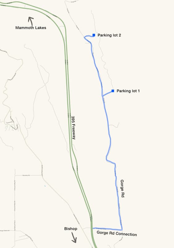
- From 395, take the Gorge Rd exit to the east (also called Gorge Rd Connection on Google Maps). I can navigate directly here: https://google.com/maps/place/37°26'42.4"N+118°33'56.0"W/@37.445114,-118.5681329
- There are two options for parking lots.
- Parking lot 1 (Leads to a 1.5-mile easy hike to Central Gorge)
- Turn left on Gorge Rd, then right on Middle Power Plant Rd. From the link in step 1, I can navigate using this link: https://google.com/maps/place/37°29'28.1"N+118°33'47.4"W/@37.4911389,-118.5631667
- Parking lot 2 (Leads to a steep gully to get to Central Gorge. Requires driving a dirt road.)
- Turn left on Gorge Rd. Keep going past Middle Power Plant Rd. Keep going until reaching a dirt road heading east. From the link in step 1, I can navigate directly here https://google.com/maps/place/37°30'32.9"N+118°34'30.8"W/@37.5091389,-118.5752222
- Drive down the dirt road about a quarter mile to reach the parking lot. Google Maps does not show the dirt road. This is the location of the parking lot: https://google.com/maps/place/37°30'35.9"N+118°34'17.3"W/@37.5099722,-118.5714722
- Parking lot 1 (Leads to a 1.5-mile easy hike to Central Gorge)
Map

Why are these directions necessary?
There have been multiple times that I went astray when navigating to Owens River Gorge. Many of the roads in this area are closed to the public, though Google Maps will still show driving directions using those roads. This has lead to some confusion as I'm sitting in my car looking at a blocked off road that my navigation system is telling me to drive on. Hopefully these directions will prevent such incidents in the future.


Comments